

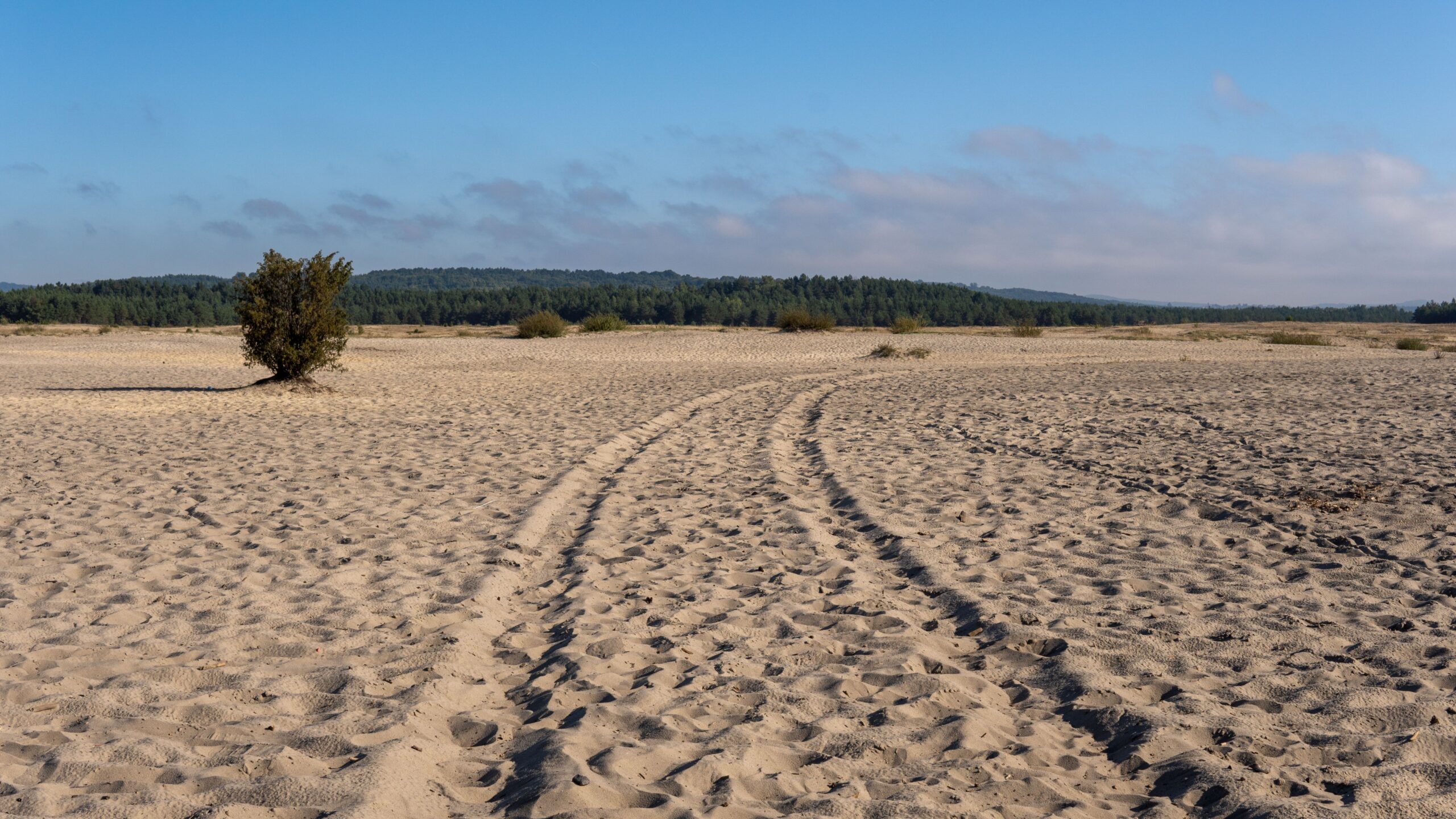
From a hilltop in southern Poland, the landscape looks as though a piece of the Sahara has been dropped into the middle of Central Europe.
Golden sand stretches across the horizon, broken by patches of hardy vegetation and surrounded by green woodland.
There are no camels, no endless dunes and no scorching desert climate. Instead, there is an extraordinary landscape created by a combination of Ice Age geology, medieval mining and centuries of environmental change.
- Find more news from Poland on our Homepage .
This is the Błędów Desert, known in Polish as Pustynia Błędowska.
Located between the Silesian and Olkusz uplands, near the towns of Klucze and Dąbrowa Górnicza, it is one of Poland’s most unusual natural attractions.
But the story behind this so-called desert is more surprising than its appearance.
The sand is ancient. The open, desert-like landscape owes much of its existence to human activity. And today, conservationists sometimes have to remove trees to stop the sand from disappearing.
How did a desert appear in Poland?
The Błędów Desert did not form because southern Poland once experienced a climate like that of the Sahara.
Its geological foundations date back to the Ice Age.
During the Pleistocene, meltwater and rivers associated with glacial and periglacial environments carried enormous quantities of sand and gravel into depressions in the region’s limestone and dolomite bedrock.
These deposits accumulated in layers that average approximately 40 metres thick and can reach around 70 metres in places.
As the climate warmed after the last glaciation, vegetation gradually colonised the sandy ground.
Forests eventually covered much of the area.
For thousands of years, therefore, the sand existed largely beneath a landscape that looked far more like the surrounding Polish countryside than a desert.
According to the Institute of Nature Conservation of the Polish Academy of Sciences, the exposed sandy terrain seen today reflects both geological processes and later human activity.
The sand itself was not created by mining or deforestation.
What changed was the vegetation and soil that had previously kept it in place.
Medieval miners helped uncover the sand
The transformation began in earnest during the Middle Ages.
In the thirteenth century, the nearby Olkusz region became an important centre for mining lead and silver.
Mining and metalworking required enormous quantities of timber.

Wood was used to construct mine shafts and underground passages, while charcoal fuelled the furnaces needed to process metal ores.
Forests growing over the sandy ground were progressively cleared to meet this demand.
The exposed soils were vulnerable to wind erosion, while farming, grazing and changes to local water conditions added further pressure.
With fewer tree roots and less vegetation to stabilise the surface, wind could carry away loose soil and move the underlying sand.
Gradually, extensive open sandy areas developed.
Research into the landscape’s history, including a study published in the geographical journal Erdkunde, identifies medieval mining and metallurgy as central to the emergence of the desert-like environment.
It was a dramatic transformation: an ancient sandy deposit hidden beneath woodland became a landscape dominated by exposed sand.
Is the Błędów Desert a real desert?
Despite its name and appearance, the Błędów Desert is not a true climatic desert.
A desert is defined principally by its extremely dry environmental conditions, rather than simply by the presence of sand.
Southern Poland receives substantially more rainfall than the world’s major arid deserts. Its temperatures and wider climate are also characteristic of Central Europe.
The Błędów Desert’s appearance is therefore the result of exposed sand, erosion and historical land use, not a desert climate.
Poland’s government educational portal describes the area as an example of human-influenced desert-like landscape development in a temperate climate.
The commonly quoted size is approximately 33 square kilometres, although this refers to a broad geographical and historical understanding of the sandy landscape.
The area of open sand has changed considerably over time as vegetation returned.
Indeed, the Polish Academy of Sciences’ geological inventory describes a smaller sandy area of approximately 17 square kilometres.
The official Natura 2000 protected area covers approximately 19.6 square kilometres, but its boundaries are not identical to those used in every estimate of the desert’s extent.
The figures are therefore not interchangeable.
One striking geographical feature is the Biała Przemsza River, which runs through the area and separates its northern and southern sections.
The river valley introduces an unexpected ribbon of greenery into the sandy landscape.
Why conservationists are removing trees
For a long time, the main environmental change affecting the Błędów Desert was the gradual return of vegetation.
Trees, shrubs and grasses began colonising the sand.
Planting schemes, including those undertaken during the twentieth century, helped stabilise parts of the ground.
Over time, this created a new problem for conservationists.
The very processes that were bringing woodland back threatened to eliminate some of the rare open sandy habitats that had developed over centuries.
These habitats support plants adapted to dry, nutrient-poor soils, including specialised sand grasslands.
The area is protected under the European Union’s Natura 2000 network as Pustynia Błędowska PLH120014.
Its conservation objectives include protecting inland dunes, sandy grasslands and the ecological processes associated with exposed sand.
Between 2011 and 2014, the municipality of Klucze implemented an EU-supported LIFE conservation project.
The work included removing selected trees and shrubs, restoring open sandy habitats, monitoring vegetation and establishing educational paths.
The project’s official account explains that the objective was to improve the condition of protected habitats while making the area more accessible for responsible tourism.
A conservation plan amended in 2023 also sets out measures to maintain a mosaic of dunes, exposed sand and sandy grasslands.
The unusual result is that, in some places, protecting nature means preventing the natural spread of woodland.
Where visitors can see Poland’s desert
Today, the Błędów Desert is an established destination for visitors interested in unusual landscapes, walking and nature.
One of the best-known viewpoints is Czubatka, a hill near Klucze offering a panoramic view across the southern sandy area.
From here, visitors can appreciate the contrast between the pale sand and the surrounding woodland.
The Polish State Forests also promote an educational walking route through the Biała Przemsza valley and the desert landscape.
The Siewierz Forest District’s visitor guide, published in July 2025, describes a 15-kilometre route that can be divided into shorter walks.
It introduces visitors not only to the sand but also to nearby wetlands, forests and the natural history of the area.
Visitors should use marked routes and observe local access restrictions, particularly around areas used for military training.
For those expecting Poland to consist mainly of mountains, forests, lakes and historic cities, the sight of such a large sandy expanse can be startling.
Yet perhaps the most fascinating part of the Błędów Desert is that it tells several stories at once.
It is a reminder of the Ice Age, the economic demands of medieval mining, the environmental consequences of deforestation and the modern challenge of protecting unusual habitats.
And that is what makes this Polish landscape so remarkable.
It looks like a desert, sits in a country of forests and survives partly because people are working to keep the sand exposed.
Featured photograph: Etcetera5891 / Wikimedia Commons, CC BY 3.0. View from Czubatka, photographed 12 June 2016; cropped from the original to 16:9.